

CUET Preparation Today
Study the map carefully and answer the question.
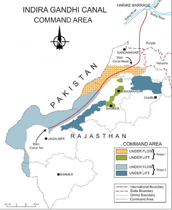
|
Identify the districts where Stage II areas are located. A. Ropar Choose the correct answer from the options given below: |
A and B only A and C only A and D only B, C and D only |
B, C and D only |
The correct answer is Option (4) → B, C and D only Indira Gandhi Canal, previously known as the Rajasthan Canal, is one of the largest canal systems in India. Conceived by Kanwar Sain in 1948, the canal project was launched on 31 March, 1958. The canal originates at Harike barrage in Punjab and runs parallel to Pakistan border at an average distance of 40 km in Thar Desert (Marusthali) of Rajasthan. The total planned length of the system is 9,060 km catering to the irrigation needs of a total culturable command area of 19.63 lakh hectares. Out of the total command area, about 70 per cent was envisaged to be irrigated by flow system and the rest by lift system. The construction work of the canal system has been carried out through two stages. The command area of Stage-I lies in Ganganagar, Hanumangarh and northern part of Bikaner districts. It has a gently undulating topography and its culturable command area is 5.53 lakh hectares. The command area of Stage-II is spread over Bikaner, Jaisalmer, Barmer, Jodhpur, Nagaur and Churu districts covering culturable command area of 14.10 lakh ha. It comprises desert land dotted with shifting sand dunes and temperature soaring to 50ºC in summers. In the lift canal, the water is lifted up to make it to flow against the slope of the land. All the lift canals of Indira Gandhi Canal system originate at the left bank of main canal while all the canals on the right bank of main canal are flow channels. |